lidar-imu calibration---lidar_align+运行liosam算法测试标定效果_liosam传感器标定-程序员宅基地
本文lidar-imu标定方法为瑞士苏黎世理工大学-自动驾驶实验室开源的一种校准 3D 激光雷达和 6 自由度位姿传感器外参的方法。
该方法需要大量非平面的运动,因此不适合校准安装在汽车上的传感器标定
代码地址:https://github.com/ethz-sl/lidar_align
测试环境:nvidia agx xavier +ubuntu18.04+ROS Melodic
lidar_align工程代码实现了以下功能:
1、读取lidar和位姿传感器的数据
2、通过时间戳匹配lidar每帧里面的每个点和位姿传感器的坐标变换
2、通过上面的变换矩阵将利用位姿信息将lidar的每帧拼接成点云
3、每个点和它最近邻点的距离总和求出,在优化中就是不断的迭代找到坐标变换使这个距离最小
算法的整体思想:
1、为每帧lidar的每个点通过时间戳去匹配一个位姿数据,并通过插值的方式得到更准确的位姿值,每个点的时间偏移也是优化因素之一
2、利用NLopt的库的非线性优化方法
3、目标函数:让拼接后的点云的每个点的最近邻点最小
4、优化向量:x、y 、z、roll、pitch、yaw、time_offset
总体来说就是不断的迭代,找到一个合适的优化向量(也就是lidar到里程计的坐标变换)使得拼在一起的点云每个点的最近邻点距离最小。
可以离线计算,录一个rosbag,然后跑一下就可以求的外参
它只会读取一个bag ,所以 lidar和位姿都要在里面
最终的结果:
在运行的时候,功能包会输出当前的估计变化
优化结束的时候 坐标变换的参数会打印在终端上
也会在路径下面保存一个txt文件和ply文件。
可以查看ply文件,就是拼接后的点云和场景是否一致
编译:
mkdir -p lidar_align_ws/src
cd lidar_align_ws/src
git clone https://github.com/ethz-sl/lidar_align
cd ..
catkin_make
编译过程中,报错如下:
问题一:编译时出现Could not find NLOPTConfig.cmake
解决方法:
下载 安装非线性优化库nlopt
sudo apt-get install libnlopt-dev
若编译还是会报错:
Could not find a package configuration file provided by “NLOPT”
解决办法:
将 lidar_align 文件夹下的 NLOPTConfig.cmake 复制到 ROS工作空间lidar_align_ws/src路径下面
问题二:源码中没有接收IMU数据的接口,需要自己改写代码,加入imu数据的接口,只要改写loader.cpp即可,改写好的代码如下,可直接替换源码中loader.cpp的代码
#include <geometry_msgs/TransformStamped.h>
#include <rosbag/bag.h>
#include <rosbag/view.h>
#include <sensor_msgs/Imu.h>

#include "lidar_align/loader.h"
#include "lidar_align/transform.h"

namespace lidar_align {


Loader::Loader(const Config& config) : config_(config) {
    }

Loader::Config Loader::getConfig(ros::NodeHandle* nh) {

  Loader::Config config;
  nh->param("use_n_scans", config.use_n_scans, config.use_n_scans);
  return config;
}

void Loader::parsePointcloudMsg(const sensor_msgs::PointCloud2 msg,
                                LoaderPointcloud* pointcloud) {

  bool has_timing = false;
  bool has_intensity = false;
  for (const sensor_msgs::PointField& field : msg.fields) {

    if (field.name == "time_offset_us") {

      has_timing = true;
    } else if (field.name == "intensity") {

      has_intensity = true;
    }
  }

  if (has_timing) {

    pcl::fromROSMsg(msg, *pointcloud);
    return;
  } else if (has_intensity) {

    Pointcloud raw_pointcloud;
    pcl::fromROSMsg(msg, raw_pointcloud);

    for (const Point& raw_point : raw_pointcloud) {

      PointAllFields point;
      point.x = raw_point.x;
      point.y = raw_point.y;
      point.z = raw_point.z;
      point.intensity = raw_point.intensity;

      if (!std::isfinite(point.x) || !std::isfinite(point.y) ||
          !std::isfinite(point.z) || !std::isfinite(point.intensity)) {

        continue;
      }

      pointcloud->push_back(point);
    }
    pointcloud->header = raw_pointcloud.header;
  } else {

    pcl::PointCloud<pcl::PointXYZ> raw_pointcloud;
    pcl::fromROSMsg(msg, raw_pointcloud);

    for (const pcl::PointXYZ& raw_point : raw_pointcloud) {

      PointAllFields point;
      point.x = raw_point.x;
      point.y = raw_point.y;
      point.z = raw_point.z;

      if (!std::isfinite(point.x) || !std::isfinite(point.y) ||
          !std::isfinite(point.z)) {

        continue;
      }

      pointcloud->push_back(point);
    }
    pointcloud->header = raw_pointcloud.header;
  }
}

bool Loader::loadPointcloudFromROSBag(const std::string& bag_path,
                                      const Scan::Config& scan_config,
                                      Lidar* lidar) {

  rosbag::Bag bag;
  try {

    bag.open(bag_path, rosbag::bagmode::Read);
  } catch (rosbag::BagException e) {

    ROS_ERROR_STREAM("LOADING BAG FAILED: " << e.what());
    return false;
  }

  std::vector<std::string> types;
  types.push_back(std::string("sensor_msgs/PointCloud2"));
  rosbag::View view(bag, rosbag::TypeQuery(types));

  size_t scan_num = 0;
  for (const rosbag::MessageInstance& m : view) {

    std::cout << " Loading scan: \e[1m" << scan_num++ << "\e[0m from ros bag"
              << '\r' << std::flush;

    LoaderPointcloud pointcloud;
    parsePointcloudMsg(*(m.instantiate<sensor_msgs::PointCloud2>()),
                       &pointcloud);

    lidar->addPointcloud(pointcloud, scan_config);

    if (lidar->getNumberOfScans() >= config_.use_n_scans) {

      break;
    }
  }
  if (lidar->getTotalPoints() == 0) {

    ROS_ERROR_STREAM(
        "No points were loaded, verify that the bag contains populated "
        "messages of type sensor_msgs/PointCloud2");
    return false;
  }

  return true;
}

bool Loader::loadTformFromROSBag(const std::string& bag_path, Odom* odom) {

  rosbag::Bag bag;
  try {

    bag.open(bag_path, rosbag::bagmode::Read);
  } catch (rosbag::BagException e) {

    ROS_ERROR_STREAM("LOADING BAG FAILED: " << e.what());
    return false;
  }

  std::vector<std::string> types;
  types.push_back(std::string("sensor_msgs/Imu"));
  rosbag::View view(bag, rosbag::TypeQuery(types));
  size_t imu_num = 0;
  double shiftX=0,shiftY=0,shiftZ=0,velX=0,velY=0,velZ=0;
  ros::Time time;
  double timeDiff,lastShiftX,lastShiftY,lastShiftZ;
  for (const rosbag::MessageInstance& m : view){

    std::cout <<"Loading imu: \e[1m"<< imu_num++<<"\e[0m from ros bag"<<'\r'<< std::flush;

    sensor_msgs::Imu imu=*(m.instantiate<sensor_msgs::Imu>());

    Timestamp stamp = imu.header.stamp.sec * 1000000ll +imu.header.stamp.nsec / 1000ll;
    if(imu_num==1){

        time=imu.header.stamp;
            Transform T(Transform::Translation(0,0,0),Transform::Rotation(1,0,0,0));
        odom->addTransformData(stamp, T);
    }
    else{

        timeDiff=(imu.header.stamp-time).toSec();
        time=imu.header.stamp;
        velX=velX+imu.linear_acceleration.x*timeDiff;
        velY=velX+imu.linear_acceleration.y*timeDiff;
        velZ=velZ+(imu.linear_acceleration.z-9.801)*timeDiff;

        lastShiftX=shiftX;
        lastShiftY=shiftY;
        lastShiftZ=shiftZ;
        shiftX=lastShiftX+velX*timeDiff+imu.linear_acceleration.x*timeDiff*timeDiff/2;
        shiftY=lastShiftY+velY*timeDiff+imu.linear_acceleration.y*timeDiff*timeDiff/2;
        shiftZ=lastShiftZ+velZ*timeDiff+(imu.linear_acceleration.z-9.801)*timeDiff*timeDiff/2;

        Transform T(Transform::Translation(shiftX,shiftY,shiftZ),
               Transform::Rotation(imu.orientation.w,
                        imu.orientation.x,
                        imu.orientation.y,
                        imu.orientation.z));
        odom->addTransformData(stamp, T);
    }
  }
  // std::vector<std::string> types;
  // types.push_back(std::string("geometry_msgs/TransformStamped"));
  // rosbag::View view(bag, rosbag::TypeQuery(types));

  // size_t tform_num = 0;
  // for (const rosbag::MessageInstance& m : view) {

  //   std::cout << " Loading transform: \e[1m" << tform_num++
  //             << "\e[0m from ros bag" << '\r' << std::flush;

  //   geometry_msgs::TransformStamped transform_msg =
  //       *(m.instantiate<geometry_msgs::TransformStamped>());

  //   Timestamp stamp = transform_msg.header.stamp.sec * 1000000ll +
  //                     transform_msg.header.stamp.nsec / 1000ll;

  //   Transform T(Transform::Translation(transform_msg.transform.translation.x,
  //                                      transform_msg.transform.translation.y,
  //                                      transform_msg.transform.translation.z),
  //               Transform::Rotation(transform_msg.transform.rotation.w,
  //                                   transform_msg.transform.rotation.x,
  //                                   transform_msg.transform.rotation.y,
  //                                   transform_msg.transform.rotation.z));
  //   odom->addTransformData(stamp, T);
  // }

  if (odom->empty()) {

    ROS_ERROR_STREAM("No odom messages found!");
    return false;
  }

  return true;
}

bool Loader::loadTformFromMaplabCSV(const std::string& csv_path, Odom* odom) {

  std::ifstream file(csv_path, std::ifstream::in);

  size_t tform_num = 0;
  while (file.peek() != EOF) {

    std::cout << " Loading transform: \e[1m" << tform_num++
              << "\e[0m from csv file" << '\r' << std::flush;

    Timestamp stamp;
    Transform T;

    if (getNextCSVTransform(file, &stamp, &T)) {

      odom->addTransformData(stamp, T);
    }
  }

  return true;
}

// lots of potential failure cases not checked
bool Loader::getNextCSVTransform(std::istream& str, Timestamp* stamp,
                                 Transform* T) {

  std::string line;
  std::getline(str, line);

  // ignore comment lines
  if (line[0] == '#') {

    return false;
  }

  std::stringstream line_stream(line);
  std::string cell;

  std::vector<std::string> data;
  while (std::getline(line_stream, cell, ',')) {

    data.push_back(cell);
  }

  if (data.size() < 9) {

    return false;
  }

  constexpr size_t TIME = 0;
  constexpr size_t X = 2;
  constexpr size_t Y = 3;
  constexpr size_t Z = 4;
  constexpr size_t RW = 5;
  constexpr size_t RX = 6;
  constexpr size_t RY = 7;
  constexpr size_t RZ = 8;

  *stamp = std::stoll(data[TIME]) / 1000ll;
  *T = Transform(Transform::Translation(std::stod(data[X]), std::stod(data[Y]),
                                        std::stod(data[Z])),
                 Transform::Rotation(std::stod(data[RW]), std::stod(data[RX]),
                                     std::stod(data[RY]), std::stod(data[RZ])));

  return true;
}

}  // namespace lidar_align
注意:改写后记得包含头文件#include <sensor_msgs/Imu.h>
否则会报如下错误:
error: ‘Imu’ is not a member of ‘sensor_msgs’
     sensor_msgs::Imu imu=*(m.instantiate<sensor_msgs::Imu>());
                  ^~~
/home/ubuntu/Sensors_Calibration/lidar_align_ws/src/lidar_align/src/loader.cpp:134:23: error: ‘imu’ was not declared in this scope
     Timestamp stamp = imu.header.stamp.sec * 1000000ll +imu.header.stamp.nsec / 1000ll;
                       ^~~
/home/ubuntu/Sensors_Calibration/lidar_align_ws/src/lidar_align/src/loader.cpp:134:23: note: suggested alternative: ‘time’
     Timestamp stamp = imu.header.stamp.sec * 1000000ll +imu.header.stamp.nsec / 1000ll;
                       ^~~
                       time
lidar_align/CMakeFiles/lidar_align.dir/build.make:110: recipe for target 'lidar_align/CMakeFiles/lidar_align.dir/src/loader.cpp.o' failed
make[2]: *** [lidar_align/CMakeFiles/lidar_align.dir/src/loader.cpp.o] Error 1
CMakeFiles/Makefile2:510: recipe for target 'lidar_align/CMakeFiles/lidar_align.dir/all' failed
make[1]: *** [lidar_align/CMakeFiles/lidar_align.dir/all] Error 2
Makefile:140: recipe for target 'all' failed
make: *** [all] Error 2
Invoking "make -j8 -l8" failed
运行LIOSAM
安装并编译好LIOSAM。
github链接: https://github.com/TixiaoShan/LIO-SAM
问题一:Error: GTSAM was built against a different version of Eigen。
这个问题是GTSAM自带的eigen库和之前安装的eigen库的版本不同导致的。
解决办法:
修改gtsam下的CMakeLists.txt文件中的内容,在if(GTSAM_USE_SYSTEM_EIGEN)前面加上set(GTSAM_USE_SYSTEM_EIGEN ON),使得gtsam使用自己安装的eigen而不是它自带的eigen。然后重新编译gtsam,之后再编译LIO-SAM,问题解决。
编译好就可以运行数据集了,运行官网数据集的时候不需要改写param.yaml。
运行自己采集的数据,需要修改你录制的话题、IMU的内参、IMU到雷达的外参以及
PCD存放路径:
# 保存地图设置为true
savePCD: true                              # https://github.com/TixiaoShan/LIO-SAM/issues/3
# 设置地图保存路径
savePCDDirectory: "自己设置的路径"        # in your home folder, starts and ends with "/". Warning: the code deletes "LOAM" folder then recreates it. See "mapOptimization" for implementation
然后,为了避免保存还没完成,ros就已经关闭了节点,需要设置_TIMEOUT_SIGINT的值。按如下命令打开文件:
sudo gedit /opt/ros/melodic/lib/python2.7/dist-packages/roslaunch/nodeprocess.py
在文件中找到_TIMEOUT_SIGINT,并设置为100秒。
这样,在命令窗口中按下Ctrl+C来结束run.launch的运行时,便会自动将pcd文件保存到指定地址。
lio_sam:
  # Topics
#  pointCloudTopic: "points_raw"               # Point cloud data
  pointCloudTopic: "velodyne_points"
  imuTopic: "imu/data"                         # IMU data
#  imuTopic: "imu_correct"
  odomTopic: "odometry/imu"                   # IMU pre-preintegration odometry, same frequency as IMU
  gpsTopic: "odometry/gpsz"                   # GPS odometry topic from navsat, see module_navsat.launch file

  # Frames
  lidarFrame: "base_link"
  baselinkFrame: "base_link"
  odometryFrame: "odom"
  mapFrame: "map"

  # GPS Settings
#  useImuHeadingInitialization: true           # if using GPS data, set to "true"
  useImuHeadingInitialization: false
  useGpsElevation: false                      # if GPS elevation is bad, set to "false"
  gpsCovThreshold: 2.0                        # m^2, threshold for using GPS data
  poseCovThreshold: 25.0                      # m^2, threshold for using GPS data

  # Export settings
#  savePCD: false                              # https://github.com/TixiaoShan/LIO-SAM/issues/3
  savePCD: true
  savePCDDirectory: "/dataset/LIO-SAM/xsens_velodyne"        # in your home folder, starts and ends with "/". Warning: the code deletes "LOAM" folder then recreates it. See "mapOptimization" for implementation

  # Sensor Settings
  sensor: velodyne                            # lidar sensor type, either 'velodyne' or 'ouster'
  N_SCAN: 16                                  # number of lidar channel (i.e., 16, 32, 64, 128)
  Horizon_SCAN: 1800                          # lidar horizontal resolution (Velodyne:1800, Ouster:512,1024,2048)
  downsampleRate: 1                           # default: 1. Downsample your data if too many points. i.e., 16 = 64 / 4, 16 = 16 / 1
  lidarMinRange: 1.0                          # default: 1.0, minimum lidar range to be used
  lidarMaxRange: 1000.0                       # default: 1000.0, maximum lidar range to be used

  #IMU Settings
  imuAccNoise: 9.7816033475532395e-03
  imuGyrNoise: 1.9958347084630267e-03
  imuAccBiasN: 8.4485975927320214e-05
  imuGyrBiasN: 2.5139562639019187e-05
  imuGravity: 9.80511
  imuRPYWeight: 0.01
#  imuAccNoise: 1.9238237446574064e-02
#  imuGyrNoise: 1.5385754496033436e-03
#  imuAccBiasN: 4.9615115224550062e-04
#  imuGyrBiasN: 5.0721205121154150e-06
#  imuGravity: 9.80511
#  imuRPYWeight: 0.01

  # Extrinsics (lidar -> IMU)
  extrinsicTrans: [-0.00201536, 0.00144471, -0.00145396]
#  extrinsicTrans: [0.0, 0.0, 0.0]
#  extrinsicRot: [-1, 0, 0,
#                  0, 1, 0,
#                  0, 0, -1]
#  extrinsicRPY: [0,  1, 0,
#                 -1, 0, 0,
#                  0, 0, 1]
#  extrinsicRot: [1, 0, 0,
#                 0, 1, 0,
#                 0, 0, 1]
#  extrinsicRPY: [1, 0, 0,
#                 0, 1, 0,
#                 0, 0, 1]
  extrinsicRot:   [-0.295055,   -0.562411,    0.772423,
  -0.438059,   -0.638821,   -0.632466,
   0.849145,   -0.524979,  -0.0578822]


  extrinsicRPY:  [-0.295055,   -0.562411,    0.772423,
  -0.438059,   -0.638821,   -0.632466,
   0.849145,   -0.524979,  -0.0578822]
  # LOAM feature threshold
  edgeThreshold: 1.0
  surfThreshold: 0.1
  edgeFeatureMinValidNum: 10
  surfFeatureMinValidNum: 100

  # voxel filter paprams
  odometrySurfLeafSize: 0.4                     # default: 0.4 - outdoor, 0.2 - indoor
  mappingCornerLeafSize: 0.2                    # default: 0.2 - outdoor, 0.1 - indoor
  mappingSurfLeafSize: 0.4                      # default: 0.4 - outdoor, 0.2 - indoor

  # robot motion constraint (in case you are using a 2D robot)
  z_tollerance: 1000                            # meters
  rotation_tollerance: 1000                     # radians

  # CPU Params
  numberOfCores: 4                              # number of cores for mapping optimization
  mappingProcessInterval: 0.15                  # seconds, regulate mapping frequency

  # Surrounding map
  surroundingkeyframeAddingDistThreshold: 1.0   # meters, regulate keyframe adding threshold
  surroundingkeyframeAddingAngleThreshold: 0.2  # radians, regulate keyframe adding threshold
  surroundingKeyframeDensity: 2.0               # meters, downsample surrounding keyframe poses
  surroundingKeyframeSearchRadius: 50.0         # meters, within n meters scan-to-map optimization (when loop closure disabled)

  # Loop closure
  loopClosureEnableFlag: true
  loopClosureFrequency: 1.0                     # Hz, regulate loop closure constraint add frequency
  surroundingKeyframeSize: 50                   # submap size (when loop closure enabled)
  historyKeyframeSearchRadius: 15.0             # meters, key frame that is within n meters from current pose will be considerd for loop closure
  historyKeyframeSearchTimeDiff: 30.0           # seconds, key frame that is n seconds older will be considered for loop closure
  historyKeyframeSearchNum: 25                  # number of hostory key frames will be fused into a submap for loop closure
  historyKeyframeFitnessScore: 0.3              # icp threshold, the smaller the better alignment

  # Visualization
  globalMapVisualizationSearchRadius: 1000.0    # meters, global map visualization radius
  globalMapVisualizationPoseDensity: 10.0       # meters, global map visualization keyframe density
  globalMapVisualizationLeafSize: 1.0           # meters, global map visualization cloud density


# Navsat (convert GPS coordinates to Cartesian)
navsat:
  frequency: 50
  wait_for_datum: false
  delay: 0.0
  magnetic_declination_radians: 0
  yaw_offset: 0
  zero_altitude: true
  broadcast_utm_transform: false
  broadcast_utm_transform_as_parent_frame: false
  publish_filtered_gps: false

# EKF for Navsat
ekf_gps:
  publish_tf: false
  map_frame: map
  odom_frame: odom
  base_link_frame: base_link
  world_frame: odom

#  frequency: 50
  frequency: 200
  two_d_mode: false
  sensor_timeout: 0.01
  # -------------------------------------
  # External IMU:
  # -------------------------------------
#  imu0: imu_correct
  imu0: imu/data
  # make sure the input is aligned with ROS REP105. "imu_correct" is manually transformed by myself. EKF can also transform the data using tf between your imu and base_link
  imu0_config: [false, false, false,
                true,  true,  true,
                false, false, false,
                false, false, true,
                true,  true,  true]
  imu0_differential: false
  imu0_queue_size: 50
  imu0_remove_gravitational_acceleration: true
适配、运行自己数据集
由于lio-sam源码中使用了参数"ring"和"time",这两个参数分别表示一个激光点所属的线束序号和当前激光点在一帧激光点云的扫描时间(例如一个16线激光雷达,ring代表了激光点在竖直方向上所属的线束序号,而time表示当前激光点相对于当前激光帧第一个激光点的扫描时间)。
在lio-sam系统启动后,会在imageProjection.cpp的cachePointCloud函数中检查输入点云数据是否包含这两项参数,如果没有,则程序会报错。
如果你使用的激光雷达,采集的数据中包含参数"ring"和"time",那么是不需要进行源码改动的,只需要改动config/params.yaml中的话题名及extrinsicRot和extrinsicRPY矩阵即可(extrinsicRot和extrinsicRPY矩阵如果设置不正确则建出的地图或出现重叠)。
自己使用其它品牌雷达采集的点云数据中往往没有“ring”和”time“参数,因此需要自己在源码中进行修改,适配自己的数据。
- 对于"ring"参数,可以参考lego-loam的做法,利用公式求出当前激光点所属线束序号
- 对于“time“参数,其实这个参数的作用是记录每个点的扫描时间,用于消除点云运动畸变,因此如果暂时不考虑点云运动畸变,则可以将与time相关代码和函数注释,不影响程序运行; 如果必须考虑点云运动畸变,则可以参考lego-loam中的方法,利用公式求出每个激光点的扫描时间
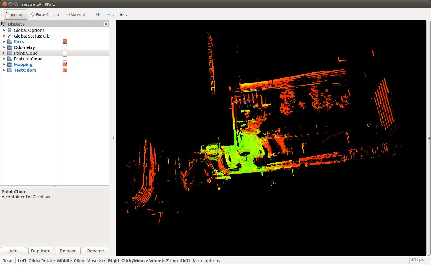
运行自己数据集效果
source devel/setup.bash
roslaunch lio_sam run.launch
source devel/setup.bash
rosbag play your-bag
未使用点云去畸变,并且按照自己设备中传感器安装关系设置了extrinsicRot和extrinsicRPY矩阵
智能推荐
攻防世界_难度8_happy_puzzle_攻防世界困难模式攻略图文-程序员宅基地
文章浏览阅读645次。这个肯定是末尾的IDAT了,因为IDAT必须要满了才会开始一下个IDAT,这个明显就是末尾的IDAT了。,对应下面的create_head()代码。,对应下面的create_tail()代码。不要考虑爆破,我已经试了一下,太多情况了。题目来源:UNCTF。_攻防世界困难模式攻略图文
达梦数据库的导出(备份)、导入_达梦数据库导入导出-程序员宅基地
文章浏览阅读2.9k次,点赞3次,收藏10次。偶尔会用到,记录、分享。1. 数据库导出1.1 切换到dmdba用户su - dmdba1.2 进入达梦数据库安装路径的bin目录,执行导库操作 导出语句:./dexp cwy_init/[email protected]:5236 file=cwy_init.dmp log=cwy_init_exp.log 注释: cwy_init/init_123..._达梦数据库导入导出
js引入kindeditor富文本编辑器的使用_kindeditor.js-程序员宅基地
文章浏览阅读1.9k次。1. 在官网上下载KindEditor文件,可以删掉不需要要到的jsp,asp,asp.net和php文件夹。接着把文件夹放到项目文件目录下。2. 修改html文件,在页面引入js文件:<script type="text/javascript" src="./kindeditor/kindeditor-all.js"></script><script type="text/javascript" src="./kindeditor/lang/zh-CN.js"_kindeditor.js
STM32学习过程记录11——基于STM32G431CBU6硬件SPI+DMA的高效WS2812B控制方法-程序员宅基地
文章浏览阅读2.3k次,点赞6次,收藏14次。SPI的详情简介不必赘述。假设我们通过SPI发送0xAA,我们的数据线就会变为10101010,通过修改不同的内容,即可修改SPI中0和1的持续时间。比如0xF0即为前半周期为高电平,后半周期为低电平的状态。在SPI的通信模式中,CPHA配置会影响该实验,下图展示了不同采样位置的SPI时序图[1]。CPOL = 0,CPHA = 1:CLK空闲状态 = 低电平,数据在下降沿采样,并在上升沿移出CPOL = 0,CPHA = 0:CLK空闲状态 = 低电平,数据在上升沿采样,并在下降沿移出。_stm32g431cbu6
计算机网络-数据链路层_接收方收到链路层数据后,使用crc检验后,余数为0,说明链路层的传输时可靠传输-程序员宅基地
文章浏览阅读1.2k次,点赞2次,收藏8次。数据链路层习题自测问题1.数据链路(即逻辑链路)与链路(即物理链路)有何区别?“电路接通了”与”数据链路接通了”的区别何在?2.数据链路层中的链路控制包括哪些功能?试讨论数据链路层做成可靠的链路层有哪些优点和缺点。3.网络适配器的作用是什么?网络适配器工作在哪一层?4.数据链路层的三个基本问题(帧定界、透明传输和差错检测)为什么都必须加以解决?5.如果在数据链路层不进行帧定界,会发生什么问题?6.PPP协议的主要特点是什么?为什么PPP不使用帧的编号?PPP适用于什么情况?为什么PPP协议不_接收方收到链路层数据后,使用crc检验后,余数为0,说明链路层的传输时可靠传输
软件测试工程师移民加拿大_无证移民,未受过软件工程师的教育(第1部分)-程序员宅基地
文章浏览阅读587次。软件测试工程师移民加拿大 无证移民,未受过软件工程师的教育(第1部分) (Undocumented Immigrant With No Education to Software Engineer(Part 1))Before I start, I want you to please bear with me on the way I write, I have very little gen...
随便推点
Thinkpad X250 secure boot failed 启动失败问题解决_安装完系统提示secureboot failure-程序员宅基地
文章浏览阅读304次。Thinkpad X250笔记本电脑,装的是FreeBSD,进入BIOS修改虚拟化配置(其后可能是误设置了安全开机),保存退出后系统无法启动,显示:secure boot failed ,把自己惊出一身冷汗,因为这台笔记本刚好还没开始做备份.....根据错误提示,到bios里面去找相关配置,在Security里面找到了Secure Boot选项,发现果然被设置为Enabled,将其修改为Disabled ,再开机,终于正常启动了。_安装完系统提示secureboot failure
C++如何做字符串分割(5种方法)_c++ 字符串分割-程序员宅基地
文章浏览阅读10w+次,点赞93次,收藏352次。1、用strtok函数进行字符串分割原型: char *strtok(char *str, const char *delim);功能:分解字符串为一组字符串。参数说明:str为要分解的字符串,delim为分隔符字符串。返回值:从str开头开始的一个个被分割的串。当没有被分割的串时则返回NULL。其它:strtok函数线程不安全,可以使用strtok_r替代。示例://借助strtok实现split#include <string.h>#include <stdio.h&_c++ 字符串分割
2013第四届蓝桥杯 C/C++本科A组 真题答案解析_2013年第四届c a组蓝桥杯省赛真题解答-程序员宅基地
文章浏览阅读2.3k次。1 .高斯日记 大数学家高斯有个好习惯:无论如何都要记日记。他的日记有个与众不同的地方,他从不注明年月日,而是用一个整数代替,比如:4210后来人们知道,那个整数就是日期,它表示那一天是高斯出生后的第几天。这或许也是个好习惯,它时时刻刻提醒着主人:日子又过去一天,还有多少时光可以用于浪费呢?高斯出生于:1777年4月30日。在高斯发现的一个重要定理的日记_2013年第四届c a组蓝桥杯省赛真题解答
基于供需算法优化的核极限学习机(KELM)分类算法-程序员宅基地
文章浏览阅读851次,点赞17次,收藏22次。摘要:本文利用供需算法对核极限学习机(KELM)进行优化,并用于分类。
metasploitable2渗透测试_metasploitable2怎么进入-程序员宅基地
文章浏览阅读1.1k次。一、系统弱密码登录1、在kali上执行命令行telnet 192.168.26.1292、Login和password都输入msfadmin3、登录成功,进入系统4、测试如下:二、MySQL弱密码登录:1、在kali上执行mysql –h 192.168.26.129 –u root2、登录成功,进入MySQL系统3、测试效果:三、PostgreSQL弱密码登录1、在Kali上执行psql -h 192.168.26.129 –U post..._metasploitable2怎么进入
Python学习之路:从入门到精通的指南_python人工智能开发从入门到精通pdf-程序员宅基地
文章浏览阅读257次。本文将为初学者提供Python学习的详细指南,从Python的历史、基础语法和数据类型到面向对象编程、模块和库的使用。通过本文,您将能够掌握Python编程的核心概念,为今后的编程学习和实践打下坚实基础。_python人工智能开发从入门到精通pdf